

Tracking Manitoba Wildfires: Stay Updated with the Manitoba Fire Map
Manitoba Fire Map: Your Real-Time Guide to Wildfire Activity in 2025
As wildfire season intensifies across Canada, residents of Manitoba are keeping a close eye on the Manitoba Fire Map, a critical tool for tracking current wildfire locations, air quality concerns, and evacuation alerts.
What Is the Manitoba Fire Map?
The Manitoba Fire Map is an interactive digital map provided by Manitoba Wildfire Service and supported by Natural Resources Canada. It displays real-time wildfire information across the province, including:
- Active fire locations
- Size and intensity of fires
- Evacuation zones
- Restricted travel areas
- Fire danger levels
👉 View the live map here: Manitoba Fire Map – Government of Manitoba
Why This Map Matters
In recent years, Manitoba has seen an increase in the frequency and severity of wildfires due to climate change, drought, and human activity. Areas such as Northern Manitoba, Parkland, and Interlake are especially vulnerable during dry summers.
Timely information from the fire map helps residents:
- Plan safe travel routes
- Stay informed about evacuation alerts
- Check smoke advisories and air quality updates
- Protect property and livestock in rural areas
🔗 Check out our Canada Weather and Emergency Alerts page for daily updates.
Tips for Staying Safe During Wildfire Season
- Sign up for Manitoba Emergency Alerts via text or app notifications.
- Prepare an emergency evacuation kit with essentials: water, medications, ID, chargers.
- Avoid outdoor fires or burning debris during high-risk days.
- Protect indoor air quality with filters or N95 masks if smoke levels are high.
- Stay tuned to local news and official social media channels for evacuation instructions.
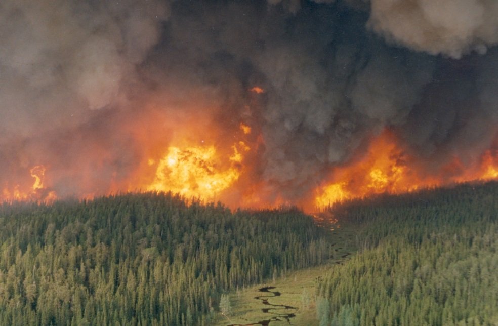
Manitoba Wildfires in 2025: What’s Happening Now?
As of this week, several active fires have been reported in the Eastern and Northern regions of Manitoba, prompting evacuation advisories for select First Nations communities.
🔥 Notable fires include:
- A large fire near Lac du Bonnet
- Blazes in Thompson and surrounding areas
- Smoke drift affecting southern towns including Steinbach and Brandon
👉 Visit Red Leaf News: Manitoba for localized fire updates.
Resources for Residents
- Environment Canada Smoke Forecast
- Manitoba Wildfire Service Updates
- Evacuation Routes & Shelters – Canadian Red Cross
Conclusion:
As wildfire season continues to unfold, the Manitoba Fire Map remains an essential resource for safety and awareness. Whether you’re a local resident or planning travel in Manitoba, staying informed can save lives and minimize risk.
Stay safe, stay alert — and check back at Red Leaf News for ongoing wildfire coverage and emergency alerts.

Art of Travel, una de las principales agencia de viajes en India, se especializa en crear experiencias de viaje personalizadas.
Con un profundo conocimiento de diversos destinos, ofrecen paquetes turísticos personalizados,
que incluyen viajes de lujo, de aventura, culturales y patrimoniales.
Desde arreglos de viaje perfectos hasta itinerarios únicos,
Art of Travel garantiza un viaje memorable para cada cliente.
Su equipo de expertos brinda un servicio de primer nivel, lo que los convierte en la opción preferida para los viajeros que buscan una experiencia de
viaje excepcional y personalizada en toda la India y más allá.
Commercial Bathroom Design: Creating Functional and Hygienic Spaces for Indian Businesses
In today’s fast-paced and design-conscious
environment, commercial bathroom design plays a vital
role in defining the customer experience, especially in India’s expanding business
landscape.
Whether it's a restaurant, shopping mall,
hospital, corporate office, or educational institution, a well-
planned commercial washroom is not just about basic functionality — it reflects the hygiene
standards, brand identity, and professionalism of the business itself.
From space planning to choosing the right materials and fixtures, commercial bathroom design in
India requires a thoughtful approach. In this guide,
we’ll explore the essentials of commercial
washroom planning, key design elements, compliance standards, and product recommendations
suited to the Indian market.
Why Commercial Bathroom Design Matters
In commercial settings, restrooms are high-traffic zones that must combine functionality,
durability,
hygiene, and aesthetics. Unlike residential bathrooms, these spaces must:
Handle heavy footfall efficiently
Be easy to clean and maintain
Ensure accessibility for all users
Reflect the brand or organisation’s values
In India, where climate, water quality, and maintenance routines differ by region, selecting
the right
layout, materials, and technology becomes even more critical.
Key Elements of Commercial Bathroom Design
1. Space Planning & Layout
Efficient layout is the backbone of a successful
commercial bathroom. Indian commercial spaces
often face challenges such as limited floor area or shared
walls. To overcome this, designers should:
Allocate separate zones for male, female, and accessible (differently-abled) users
Ensure sufficient number of urinals, WC cubicles, and washbasins based on footfall
Use partitions to ensure privacy in cubicles
Plan for easy traffic flow with designated entry and
exit points
2. Material Selection
Durability and water resistance are key. Popular choices in India include:
Wall & Floor Tiles: Anti-skid vitrified or ceramic
tiles that are easy to clean
Countertops: Quartz, granite, or compact laminate for stain resistance
Partitions: High-pressure laminate (HPL) or
stainless steel for durability and hygiene
At Intellect Outsource, we offer expert Amazon product upload services to streamline your
eCommerce experience. Our team specializes in accurately uploading product listings, optimizing titles,
descriptions, and keywords for maximum visibility.
With a deep understanding of Amazon’s algorithm, we ensure your
products reach the right audience. Whether
you’re a startup or a large business, we handle bulk uploads, product categorization, and inventory management to boost
your online sales. Let us take the hassle out of managing your Amazon store, so you can focus
on growth and customer satisfaction.
I have read so many articles or reviews on the topic of the blogger lovers except this post is truly
a nice post, keep it up.